Claeys Road Diaries
“Of all the paths you take in life, make sure a few of them are dirt" ~John Muir
As most of you already know, Dave and I made a conscious decision to quit our perfectly fine jobs to travel around the U.S. over the last year. When we shared the news of our decision, there were so many people who said things like: “That is my dream!”; “I’ve always wanted to do that”; “That’s what I’m going to do when I retire”. Could we have waited until we retired? Maybe. But, we aren’t on the same retirement schedule so there was that. And, more importantly, we were compelled NOT to wait because we did not want to chance something happening to one or both of us that would prevent us from being able to do this one-in-a-lifetime trip. Plus, we knew we’d be doing a lot of hiking so we wanted to do it while we were both physically able to. If we waited five or ten years there was certainly a possibility that our bodies just wouldn’t be able to keep up or worse, that we might be faced with a fatal illness. So, for us, we knew we couldn’t put it off and we are so glad we didn’t.
During our travels, we had the most fortunate opportunity to reconnect with family and friends and make new friends which was definitely one of the highlights of our year. Sadly, for some, things unexpectedly changed for them since we last saw them. We met a lovely couple in Colorado last July and spent a fun-filled afternoon with them in the bar. They invited us to visit them in Plant City, Florida so we took them up on it. We went to their home for dinner and had a great evening and even surprised them a second time on an unexpected trip back across Florida. We made fast friends and hoped they might visit us in N.J. Sadly, not long after our last visit we received an email that Linda was diagnosed with Alzheimer’s and they’ve since had to sell their home in the country and move into a condo closer to family. We’re not sure Linda will remember meeting us. We stopped in to visit Dave’s first wife Belinda’s sister and her family in California last October. We parked the RV in their driveway and spent several days with them catching up on so many years gone passed. About 2 months ago, we got the news that Dee was hospitalized and then diagnosed with Stage 4 ovarian cancer. She is currently undergoing chemotherapy and her autistic son is having difficulties dealing with her illness. We visited an old friend and colleague, Eric and his wife Kim in Phoenix in December. We hadn’t seen them 7 and 14 years respectively. We had such an enjoyable visit – great conversation, lots of laughs and delicious home-made pancakes! We received bad news from Eric just a few days ago that he is in Stage 5 renal failure and needs a kidney donor ASAP. We are hopeful he finds a match soon. While we were in Florida, we paid a visit to Dave’s Aunt Lil and spent a lovely afternoon reminiscing about the past and learning things about his Mother’s family we hadn’t known before. I had never met her so it was nice for me to put a face with the name and she was so delighted to see her “handsome” nephew after nearly 30 years. She passed away 2 weeks after our visit. Lastly, our beloved Bing, Belinda’s father, Mike’s and Matt’s grandfather, had some health issues in 2017 that forced him into a rehabilitation center. We surprised him with a visit last September which lifted his spirits and ours. Had we been in N.J., this likely would not have happened. We went back again for a few days in early December and then, again, at Christmas. Mike and Matt flew out and the six of us got to be together on Christmas for the first time in 15 years. And, as a bonus, we were able to help Bing & Mac celebrate their wedding anniversary on 12/26 which was such a joy and treat and a memory forever etched in our hearts. After Christmas, Mac voluntarily moved Bing home and orchestrated in-home rehab enabling him to regain strength and get back some lost independence. Things were looking up for him. And, then, out of the blue, last Saturday, we got the dreaded phone call that Bing had taken a turn for the worse. His body was shutting down. He passed away the very next day.
So, you see folks, this is the stuff Dave and I were worried about. The things you cannot predict that completely turn your live upside down in a blink of an eye. We are so incredibly grateful for the chance to be with these 5 people and all the others throughout our travels. We know how fortunate we were to be able to take a year off from our regular, working lives to explore the country and live out our dream. We do not take any of it for granted. So, at the risk of sounding preachy, I am compelled to remind you that LIFE IS SHORT. There are no guarantees. The clock ticks, the years pass and our bodies tend to slow and weaken. There are any number of things that can sneak up on you and topple your world. Get off that couch! Take a walk in the woods. Swim in the ocean. Open that special bottle of wine. Book that dream vacation! Call that friend you’ve been meaning to but just haven’t found the time. Go visit your loved ones whom you haven’t seen since you cannot remember when. Get out that bucket list and start checking things off! And if you don’t have a bucket list, make one. Don’t wait to get to the end and say; “Oh, I wish I would’ve done that, gone there or said that”. Don’t regret the things you didn’t do or meant to do. Stop putting it off until tomorrow. Live for today. Carpe Diem!
. 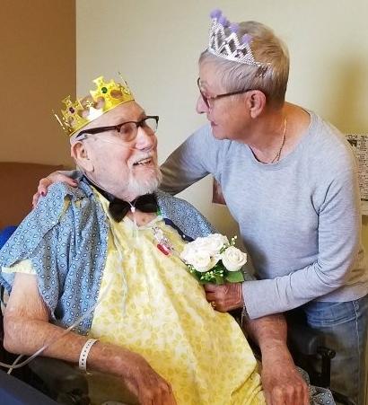
Warner “Bing” Bordier, March 3, 1932 – July 15, 2018


As most of our nations National Parks are west of the Mississippi, this back end leg of our trip could result in a lot of driving with very few stops to admire our park system as we swing our RV up the east coast. Fortunately, the east coast is dotted with the history of our countries bloodiest war and that was the Civil War. Historical sites which include numerous National Historical Parks and Battlefields are no less amazing than the natural beauty that was in our National Parks. Every battle that was fought is a fascinating story of bravery, savagery, untold losses, and more often than not, monumental blunders by those in command, seemingly more often than not by the Union forces. You cannot but imagine the level of commitment to “the cause” on both sides as they endured charges across open fields into a barrage of musket and cannon fire, brutal bombardments by artillery batteries, hand to hand combat, bayonets as a handier means of killing than reloading their muskets, field doctors removing mangled limbs with saws and without anesthesia, anguished deaths of the wounded laying in the fields after the battle has ended, endless marches through all manner of weather, lack of food and adequate clothing, and the pitting of brothers and friends against each other on American soil. I wonder at the different factors that actually fueled the commitment. If you were a Confederate soldier, were you fighting this hard to protect the institution of slavery or states rights? Were you fighting to protect your homeland, the South, from Northern aggression? If you were in the Union army, were you fighting to maintain a unity of the states? Were you fighting because you were against the institution of slavery? Or maybe, some continued fighting because they had already been through the hell of battle and loss and deprivation and your anger moved you to take it out on the enemy. Something must have fueled the incredible bravery shown by these fighting men. It’s the type of bravery that keeps you fighting regardless of the odds against you. It’s the type of bravery that turns the tides of battles. Every battle and engagement is a chapter in this story that on its own, cannot be put down, and regardless of the side of the Mason Dixon line on which you fall, you cannot fail to shed a tear when hearing the recounting of these battles in which so many young Americans died. They are battles that made up a war of unbelievable tragedy.
Our first stop was Fort Sumter, situated in the harbor of Charleston, South Carolina. This was where the first shots of what would be the start of the Civil War took place. By 1861, 6 southern states had voted to seceded from the Union when Maj. Robert Anderson moved his two companies of Federal forces (Union) from an unprotected position at Fort Moultrie on the Charleston harbor, into Fort Sumter which currently was empty. The State of South Carolina considered this a “breach of faith”, and ordered Anderson to vacate the fort. Anderson in turn was ordered by the Union President James Buchanan to hold the fort. Later that year when Lincoln was elected, he too supported the holding of the fort with Anderson’s forces, as he did not recognize the splitting of the Union. He also stressed that the Union forces would not fire on anyone from the fort. This was not acceptable to the secessionist state of South Carolina and the southern Secretary of War ordered General Pierre B. T Beauregard of the CSA (Confederate States of America) to drive the Federal forces out. After preparing batteries around the harbor, Beauregard ordered Anderson to vacate the fort or he would commence bombardment of it. Anderson refused and on April 12th, 1861, the canon batteries around the harbor began the bombardment of Fort Sumter. Anderson held out for 34 hours before surrendering. General Beauregard had been a student of Andersons when Anderson was an instructor at West Point and the two knew each other well. Beauregard allowed Anderson and his men to board a ship that took them back to New York. Fort Sumter was back under command of the Confederate States of America. Although not one soldier was lost on either side during the siege, this became the starting point of a war which would kill or wound over 300,000 men over the next 5 years.
The first official battle of the Civil War after Anderson and his Federal Brigades were forced from Fort Sumter, was the Battle of Manassas, as the Union called it, or, the Battle of Bull Run as the Confederates called it. Manassas is only 25 miles southwest of Washington DC and the North felt that this would be a quick battle and end of the secessionist conflict and that would be it. The Union General Irvin McDowell planned on taking the strategic railroad junction at Manassas Virginia and use it as a jumping off point in then taking the city of Richmond Virginia, which was the secessionist states capital. McDowell had approximately 35,000 fresh recruits who had quickly been brought together on 90 day enlistments. None had ever been in battle or had any idea what war was like. It was the same for the 32,000 troops that were under the command of Confederate General Pierre G.T. Beauregard. It would be a clash of two green and untested armies. The two armies battled back and forth for 10 hours before 10,000 Confederate reinforcements under the command of General Stonewall Jackson arrived and helped turn the tide of battle in favor of the South. The Union forces retreated in what turned into a rout by the Confederate forces. The Confederate victory did much to embolden the Confederate armies but didn’t at all dampen the moral or resolve of the North. What was clear after this battle however, was the fact that this war was not going to end quickly. It was going to be a long drawn out and bloody conflict. The National Park Service does an amazing job of maintaining these sites and they have volunteers who are truly experts on the Civil War, who give tours. We walked out along the battlefield and received a detailed accounting of the events as they transpired. It was humbling to walk over the ground where so many had suffered and died in this first true battle of the Civil War.
It is amazing to me the points on which battles and wars are turned and in my limited studying of the Civil War, one of the most significant was the battle of Antietam in Sharpsburg Maryland. I could include the outcome at the Battle of Gettysburg but we hadn’t been there on this trip. General Robert E. Lee led his army of 40,000 men across the Potomac River and into Maryland with the goal of acquiring supplies and ultimately putting a siege on Washington DC with hopes of forcing an end to the war. At the same time, England was debating the support of the Confederate States which would immediately give legitimacy and war material to the Confederacy which in turn would significantly impact the outcome of the conflict. England was dependent on the Confederate states for cotton and other crops and receiving British support represented a potential turning point for all involved. The decision to debate and support the Confederacy in the British Parliament, would depend on the Confederacy succeeding in one more major battle with the Union. The Battle of Antietam would be watched closely by the Brits. General Lee had divided his army in order to rout the Union troops that were guarding Harpers Ferry which was an armory (storing weapons for the troops). The Union General George B. McClellan was in Maryland when one of his soldiers found a copy of General Lee’s “Special Order 191, which outlined Lee’s plans and also the fact that at this point his army was divided. McClellan realized this was the time to attack and he did, driving Lee’s forces from mountaintop positions around Harpers Ferry. Lee contemplated retreating his forces back to Virginia but instead, decided to make a stand with all his forces brought together at Sharpsburg Maryland. This would be the Battle of Antietam, which was named after the creek that ran through the area. On September 17th, 1862, the battle began. Back and forth it raged. Bridges that afforded crossing of the creek were staunchly defended by the Confederates. Eventually, General Ambrose Burnside was able to take the lower bridge and drive the Confederate troops back. In the 10 hours of bloody fighting, the lines of battle had not shifted significantly, however, of the 100,000 troops that were involved in it, 23,000 were either dead, wounded or missing. It was the single bloodiest day in United States history. Although the battle was a draw, Lee decided to take his forces back across the Potomac into Virginia, leaving the Union forces in control of Sharpsburg. The South was denied a significant victory. Three months later President Lincoln issued “The Emancipation Proclamation” freeing the slaves in the secessionist states. Slaves could flee the south and even join the Union Army which they did. The Emancipation Proclamation and the Battle of Antietam, which was viewed by England as a Confederate loss, ended the British Parliaments support of the south. While the war would continue for several more years, this was a major turning point. It’s hard to say exactly what the full impact was of finding General Lee’s “Lost Order”, but it certainly played a roll in the “draw” at Antietam, and the subsequent view of the British of it being a Confederate loss. One other point of note with this battle was a local woman, Clara Barton, who seeing the carnage taking place, made numerous deliveries of bandages, lanterns, and food to the hospital that had been set up at Antietam. The hospital surgeon Charles Dunn, called her “The Angel of the Battlefield”. In 1881, Barton founded the American Red Cross, which would go on to provide neutral assistance to soldiers in war and also to civilians who were affected by natural disasters.
After almost 5 long years of this bloody conflict, the end finally came on April 9th, 1865. Gereral Robert E. Lee’s army of Northern Virginia, was boxed in by General Ulysses S. Grant near Appomattox, Virginia. Lee’s 28,000 troops were starving and short on necessary supplies and were blocked from hooking up with other Conferderate forces in North Carolina. Desertions were also running high so seeing no way out, Lee sent a message to Grant inquiring about what the possible terms of a surrender were. The terms were generous and respectful and General Lee respected the consideration from Grant throughout the rest of his life. All officers and enlisted men were to receive a full pardon upon laying down their weapons and surrendering their colors. They were also allowed to keep their horses as the spring planting was coming up and officers were allowed to keep their side arms. In addition, Grant ordered that food rations be delivered to all of the Confederate troops. As the first of the Confederate troops marched past the Union troops, the Union band struck up a celebratory tune at which Grant immediately ordered them to halt it. Instead, the Union forces stood at attention and saluted the passing Confederate troops, in a show of respect to those who were now again part of the United States of America. I cannot imagine the emotions of this moment and will freely admit that I tear up when imagining it. An interesting note about the surrender is this: the first land battle of the Civil War was fought at Manassas or, as the south called it, the first Battle of Bull Run. An individual by the name of Wilmer McClain had a farm near Manassas and after that battle, decided to relocate to a quieter location to get away from the war. He moved to Appomattox, Virginia, which was the location of the last battle of the Civil War. In addition to being present for the first and last battles of the war, it was in the parlor of his home at Appomattox where General Lee tendered his formal surrender to General Grant. There are so many fascinating battlefields and historical sites to visit that are associated with the Civil War that I have thought about doing another trip in the RV just to try and visit half of them. The history of our country and this conflict, even through just the handful of sites we visited, would be well worth it.


No disrespect meant for Ohio, but when we started our trip 10 months ago, we didn’t realize there was a National Park in the Buckeye State, and we drove right by it. Who would have thought? So, here we are again, up in the northeast corner of the state to visit Cuyahoga Valley National Park. Cuyahoga is the name of the river that runs through it and it’s an American Indian name meaning crooked, which is how the river runs its course, bending and twisting through the Cuyahoga Valley. It’s been a long, cold, winter back east since we’ve been back and CVNP offered us our first real respite from it’s icy, windy, grip. Our first two days here gave us hope that spring was on the way by blessing us with two sunny, warm, days with temps in the sixties. It was the perfect weather for hiking the relatively low hills and mountains here on the edge of the mid-west. It was also the first signs we’ve seen that spring is trying to make its entry into the seasonal sequence. We were treated to a variety of living things that were also taking advantage of the weather to make their presence known. There were a plethora of flowers that were beginning to bloom on the forest floor. The trails were frequented by small garter snakes as well as a larger black one that was lounging in a hollowed out tree trunk. Butterflies and caterpillars were starting to appear and a pair of Mallards were enjoying an abundance of fresh plants growing on the bottom of Kendal Lake. We marveled at a tree trunk that was sculpted by beavers who apparently gave up eating their way through a large tree. The warm weather also brought out a large number of park visitors who like us, had the first real reason in a long time, to get out of the house and back into nature. The large numbers of visitors are also due to the parks close proximity to Cleveland and Akron. CVNP is not as dramatic as the National Parks we’ve been visiting and has more the feel of a state park. It does however, have a number of unique features like the Ledges, which are large, eroding, sandstone blocks that you can hike among. The Ohio and Erie Canal, though not used anymore, runs through the park and provides a glimpse of the history of the area. There is a scenic train that runs through the park and offers visitors a number of different activities and of course there are miles and miles of hiking trails. The park was established in 2000 and was part of the National Park Services efforts to place National Parks closer to urban areas to give more people access to nature. On that and many other levels, Cuyahoga National Park succeeds.
Back in early March Dave said he wanted to stop in NJ on our way north and I said “No way!”. I was vehemently against the idea. I didn’t want to go home; not yet. It would feel too much like our trip was ending, or worse: over. But honestly, since Charlotte, NC, the weather hasn’t been great. We mostly endured cold, rainy days with a nice day sprinkled in here and there. It was a typical Spring, but we hadn’t really considered that last June when we began our journey. Then, when we arrived in Shenandoah National Park in Virginia, the campgrounds were not open yet and it snowed the next morning causing nearly 60 miles of Skyline Drive to close due to snow & ice. We checked the weather forecast and it was more of the same for the next 7 days. So, what do we do? Do we camp outside the park and stay the course in spite of the nasty weather? Is it just something to check off the list or do we want to enjoy it ‘in season’? How long before the trees bud and the flowers bloom?
The conversation came back once more to going home for a respite but, again, I fought against it. Dave assured me it would just be a short ‘break’ to allow the winter to have its final hurrah and Spring to arrive. He argued that we could get some unpacking done and so many other things accomplished rather than leaving it for June when we return. He planted the seed and waited for it to germinate. And we went on with our trip traveling through Virginia, D.C. and Maryland visiting Civil War battlefields, national monuments and family and having a great time. And, then, while we were in Maryland, out of the blue, Dave cracked a tooth. Crap!
So, the decision was made for us; we were going home to see a Dentist. I wasn’t thrilled by the idea but I had an awful earache that I was sure was not good news so I figured I could see my doctor to see what was going on. And, also, I realized I had a book club meeting that Thursday so I became very excited about joining the group live and it was all I could do to contain my excitement. We talked and planned out our schedule for the week. We agreed it would be best not to announce our return and simply sneak in and out without much notice so it felt more like a pit stop versus a return. With two exceptions: (1) I would go unannounced to book club; and (2) Dave would go to the school and surprise Debbie. Other than that, we would go to doctors, unpack, schedule RV maintenance, complete tax returns and then be on our way again. We were NOT going to get too comfortable.
After visiting the Naval Academy in Annapolis, Maryland on Easter Sunday, we made our way North towards New Jersey. Oddly, our cousin Bev made a comment on an earlier Facebook post when we were in Georgia, I believe, that we’d likely be home by Easter (at the rate we were traveling). I laughed then but here we were heading home on Easter day. I thought we might drive a short while and camp and complete the trek in the morning but Dave insisted on driving through. We hadn’t driven much at night during our trip except for those first few days when we set out last June rushing to get to Iowa for our RV appointment. I don’t care for driving at night mostly because you cannot enjoy the scenery and also because there are a ton of tractor trailers. But, by now, I was really anxious to get home. Owassa. “Our little piece of heaven”.
As we made our way from Maryland to New Jersey one of the first things that caught my attention were the license plates. It seemed all of a sudden there were a large number of New Jersey plates. Something we hadn’t seen it for nearly 9 months! And, oddly, it was not comforting, but rather off-putting. NO! We aren’t back in NJ. No, let’s go back. But Dave drove on and the signs became familiar and the traffic was heavy and then we arrived in Sussex County: “Nature and People Together”. And, although it was late and completely dark, when we were about ten minutes from home, Jackson jumped off the couch and came up front to sprawl on Dave’s lap. He craned his neck toward the windows watching the road intently. How do he know??
I was excited about sleeping in my bed after 9 months on an air mattress (actually, four different ones but that’s another story!) but I realized as we got closer to home we weren’t going to have water in the house. No toilet. No shower. Nothing to drink! But, by the time we arrived around 11:30pm I was too tired to care. We plopped into bed and slept soundly in our home-away-from-home retreat, now our permanent home that we haven’t settled into because we’ve been on the road for 9 months. We awoke Monday morning to SNOW! Beautiful, but not what we wanted to see, exactly. Dave immediately got to work on the water and I tackled the many boxes/bins in the living area. After, of course, going to the RV to brush my teeth and pee. What a task; to unpack things from our 2,000 something square foot house and to find space for them in a 1,300 square foot home. And, then, we saw two comments from neighbors on Facebook saying they saw us ‘home’. Oh, no! The secret was out! But we were going to ignore them and hope we wouldn’t be discovered.
We went to the doctors: Dave got a root canal and I was diagnosed with TMJ. Of course! We have been paying $2,300 a month for medical insurance but we do NOT have dental! %$^*#(@! We took the RV in for service, unpacked boxes and organized cabinets and closets, finished our taxes, all the while staying off social media as to not divulge our location. I showed up at book club Thursday night and was delighted in the surprise gasps and I spent my first night away from Dave and Jackson in over 9 months! Friday morning Dave pretended to be a transfer student and surprised Debbie in her classroom. It was fun! And, then, that night, we announced via Facebook we were home, temporarily. And once we did that it became clear that we couldn’t sequester ourselves. It was OKAY to visit and reconnect. It didn’t mean we were ‘back’, but simply visiting.
We spent time with family and friends and even went to our local haunts. Jackson had play dates with Molly and Taz (and did VERY well with his old pals!). It was great. But, it started to feel a little too comfortable. A little too familiar. I started to second guess myself and thought maybe we should just stay; get back to work and making money. I mean, we’ve had a great experience. Nine months. That’s enough, right? Why be greedy? But, I knew in my heart of hearts that we were not done. We planned on 12 months and by God, we were going to do 12 months. If we don’t finish this now, we won’t get another chance for many years. We were just waiting for the weather to turn and then it was back on the road.
And, so, during our pitstop, I took pleasure in the luxury of a full shower (constantly running water that is), a comfortable bed, larger living space, our beautiful lake and the company of our friends and family. I enjoyed every minute of it but I wasn’t ready for it to last. I was anxious to get back in the RV and hit the road. And then, unexpectedly she failed us. We weren’t getting any power to the house batteries and the scent of propane permeated around the rig. No power; no propane; no deal. Dave called to schedule repairs and they were booked until mid-May. I thought maybe it was the universe telling us we should call it quits. Game over. BUT, he called back to say it was an emergency and they agreed to fit us in. Our friend and fellow RV’er, Bob Kelley, came to our rescue for like the hundredth time and got our solar panels functioning again. Power, check. Propane, check. Back in business.
As I sit here Sunday night preparing to depart again for the road it is, honestly, with mixed emotions. I have so enjoyed being here at the lake, our new full-time home with all it’s awe and splendor, with our wonderful neighbors and friends and the birds and foxes and deer. And, without saying, being able to connect family and friends has been so great. BUT, there is that part of me that aches to be back on the road; to complete the journey we set out for last June. I am excited to visit the last three national parks on our list and other beautiful spots in the northeast. I’m ready; it’s time! The weather forecast is better, not great, but better than it was two weeks ago. And we got so much accomplished in our two weeks home. Our hearts are full; our souls are enriched. We purged the RV; will be traveling lighter in the last 2.5 months. She’s washed and ready to go. It is with happy, full, excited hearts that we set out on this final trek of what could only be explained as the best damned freaking adventure of a lifetime ever. Audios! See you in June, friends.


After spending the last couple months traveling along the essentially flat terrain of the gulf coast, Florida, and the Carolinas, the Smokey Mountains are a welcome and surprising change. These are real mountains so don’t listen to anyone who comes from Colorado and tells you otherwise. Some of the peaks rise to almost 6,000 feet with quite steep terrain and vertical gain. This range of mountains in the park are old but still majestic and the Appalachian Trail runs some 70 miles right up through the middle of the park. It’s still winter here and most of the deciduous trees have not even begun to pop leaf buds which gives the mountains a somewhat bare look. There are sections of pines in them though and also very large areas of Rosebud rhododendrons that give green to the forests. In addition, much of the forest floor is covered now with the green leaves of flowering plants and ferns which will soon explode when the warm weather comes. It’s still winter but there are signs that spring is on the way. Small, dainty flowers of yellows, purples, and whites are starting to bloom on the forest floor; some butterflies are starting to appear; black bears are starting from their winter lairs in standing hollow trees; Rosebay rhododendrons are spreading their year round leaves; and the last remnants of snow at the higher elevations are melting away (although more storms are possible and likely before spring settles in for good). The forest floor is covered with boulders, fallen trees and limbs, various fungi, lichens, and amazing mosses that exhibit the most vibrant of greens that would make the Irish proud. In spite of the lack of leaves, all of this creates a rich viewing area and a most enjoyable area to hike in. Most of the wildlife is still enjoying winters slumber and there wasn’t much to be seen. We were treated however to a mother Black Bear and at least one cub that were high up in the hollow of a tree that Laurie spotted while we were hiking the Smokemont Loop Trail. We did see some birds and butterflies and one squirrel but that was about it. There is a reason though that GSMNP is an International Biosphere Reserve as well as a designated World Heritage Site. It has more species of tree’s than northern Europe, over 1,500 species of flowering plants, dozens of native fish, over 200 species of birds, and over 60 species of mammals. There are also rare salamanders found only in this park as well as other amphibians and reptiles. If we were to pass through a little later in the season many of these would have been apparent to us. There is also much evidence to be found in it of the cultures of the Cherokee’s as well as the original white settlers who forced them out. The historic cabins, mills, etc. on the Cave Cove loop road are testament to that. There are also a number of historic buildings around Elkmont Campground that were owned by the people who were displaced when this area was authorized as a National Park in 1926 and finally established in 1934.
The Smokies got their name, “shaconage”, from the Cherokee Indians who were the original inhabitants of this area. The name translates into “blue, like smoke”. If you cross north/south in the park on Newfound Gap Road, the vistas at the higher elevations will in fact confirm that they do look blue and smokey. The mountains now are not lush and green yet and we wished we might have been here at least a month later into the spring to enjoy that, but, if we are to be back home by late June, we need to keep moving. The upside at this time of the year was that the three campgrounds that were open had plenty of availability on a first come first served basis. Once April comes around, campsites are only available by reservations made about a year in advance. It was surprising to learn that GSMNP is the most visited National Park in the entire system since it competes with some other big ones like Yellowstone, Yosemite, and Grand Canyon. It receives more visitors than any other! The reason is that unlike the many parks located out west, GSMNP is close to a multitude of densely populated areas and it is accessible via a number of major roadways. This causes intense usage during the summer so it is recommended to try to get here in spring or fall when school is still in session and the crowds are lighter. Actually, we encountered a large number of visitors even at this time of year as the weather was reasonable and, many college students were here hiking while they were on spring break! Another benefit at this time was that there weren’t any flying insects yet and the daytime temperatures were actually quite pleasant. On varying nights, we had temperatures in the low twenties as well as in the high forties with daytime temperatures that on one day reached up into the eighties! We spent three days in the park and then cut it short due to rain that had moved in. During the three days here we were able to do hikes that included 5.5 mile Little River/Cucumber Gap trail, the 5.5 mile Abrams Falls Trail, the 2.5 mile Laurel Falls Trail, and the 6.5 mile Smokemont Loop Trail. None of these trails were very demanding and we were pretty much just getting our hiking legs back after 2 months off on our aforementioned travels along the gulf coast, Florida, and the Carolinas. We also made a drive of the Caves Cove Loop with the many historic buildings that were on it and this is a worthwhile visit although travel along the eleven mile loop can be very slow due to bicyclists and slow driving “gawkers”, even at this time of the year. I can’t imagine it in the height of the summer. The park is criss crossed with innumerable creeks, streams, and rivers with crystal clear waters as the area does receive a fair amount of rain throughout the year. The higher elevations of the park receive upwards of 85 inches of rain per year.
The park was established due to concerns about the clear cutting of the forests by commercial logging companies and although that has been stopped, this beautiful park is still under attack. There are many sources of pollution like automobile exhaust from nearby population centers as well as the many cars that fill the park during the summer. Power plants, especially coal burning power plants to the west of the park, pollute the park with particulates, ozone, acid rain, and nitrogen. There is no such thing as clean coal! This pollution reduces visibility in the park up to 40% in the winter and 80% in the summer. The ozone damages plants and is also a major irritant to human respiratory tracts and eyes. The acid rain damages trees and releases aluminum and other metals in the soil that are toxic to plants and life in the streams and rivers. GSMNP used to be home to 75% of the worlds Fraser fir trees. That changed when an invasive insect called the balsam woolly adelgid was inadvertently brought into the United States on tree stock from Europe. This tiny in sect, which burrows into the bark of the tree and sucks its sap, and has now destroyed most of the mature Fraser firs in the park. This is especially evident at the higher elevations. Birds and other organisms that call the Fraser fir home have also declined in numbers as the trees have died off. We have run into problems with wild hogs in Texas and North Carolina and other states and its no different in this National Park. These non-native and fast reproducing animals destroy plants, historic landscapes, and compete with native species for foods like oak and hickory nuts. The rich bio-diversity of this park is also a magnet for humans who poach plants and other materials. The illegal gathering of ginseng roots, mosses, lichens, galax, ornamental plants, and even rocks, destroys landscapes and habitats for the parks wildlife. There is another type of adelgid that was introduced here from China and Japan and that is the Hemlock Woolly Adelgid. The park rangers are treating a number of areas for this invasive species and they have also introduced a beetle that feeds only on this adelgid and will hopefully bring it under control before the Hemlocks suffer the same fate as the Fraser firs. Last but not least is a native pest called the Southern Pine Beetle, which causes the death of pine trees. These trees are home to the threatened red-cockaded woodpecker that nests in them. When the tree’s go, so do the birds. With all of these threats facing the park, you would think that forest fires would also be on the list. Forest fires actually have many beneficial effects on the health and livelihood of the forest. Fires destroy many of the Southern Pine Beetles when they occur and all of the pine trees are not necessarily destroyed by the fire. This is good. In addition, there are many types of pine seeds that require the high intensity heat of a fire in order to germinate and this sets the table for an abundance of new pines to fill in the burned areas. The blanked areas are also excellent for native plants like mountain fetterbush, climbing fumitory, and the uncommon wildflower called Blue Ridge Mountain banner to get a foot hold now that sunlight can reach the area. All is not positive with the fires though as the burned out areas offer a free range to non-native invasive species of plants and trees to move in as well. Examples of these opportunistic invasives are kudzu, oriental bittersweet, princess trees, and mimosa trees. It requires continuous diligence by not only the employees of the National Park Service, but also all of the citizens who take advantage of this beautiful park to ensure that future generations will be able to enjoy it the same way that we are. The Smokies are a great destination, no matter what time of the year you decide to visit them. Lets keep it that way.


Congaree National Park, which is located in the north central part of South Carolina, is not an easy park to get to. There aren’t any major roads that lead directly to it and to make matters more difficult, there isn’t any camping to speak of in the park. I believe there are 10 tent sites in the park and the closest campground with hook ups is about an hour away in a State Park. All of these factors most likely account for its relatively low visitation rate. It is however one of the last remaining lowland old growth hardwood forests in the United States. 99% of this type of forest that was here in America in the “beginning”, have now been logged and destroyed. It is also a major watershed area and is located within the flood plain formed by the convergence of the Congaree River and the Wateree River that then forms the Santee River. This park is wet and contains many creeks, pools of water, and “muck”! During the winter/spring rains, flood waters can rise ten feet or more in the park, closing trails and boardwalks. On our visit fortunately, it was wet but not flooded, in spite of the 2 days of rain while we were here. Even though it was still officially winter, we had been warned that it was already hot up here in the park and the mosquitos were already out. It was actually quite pleasant and cool when we got here and on our first day at least, we didn’t have any mosquito problems. Our first day had us doing a two and a half mile nature walk through misting rain on a raised boardwalk through the floodplain and we were pleasantly surprised to not encounter any of the flying pests. It was our first opportunity to take in the solitude and ecology of this giant floodplain and especially the tree’s and plants that make it home. Day two however had us on a 5 mile hike that took us out along Cedar Creek and the mosquito throngs were out in force. Most likely, no less than the lives of 40 or more of them succumbed to my slap assassinations, and many of them released a drop of my blood as evidence that they had already successfully drained it from me before their death. It’s not that I would begrudge them a drop or two of my blood if that was all that was at stake, but they have to inject an anti-coagulant into your skin in order to get the blood flowing and that is a foreign protein that causes intense itching. In addition to the itching annoyance, you might also be the recipient of a virus or parasite, which is enough justification for our role in their demise!
Our day two hike along the creek gave us the opportunity to observe and photograph more of the flora and fauna that you find in Congaree. Everything in life is a tradeoff and the time of the year of our visit is no different. Arriving here in the beginning of March has us avoiding the heat, the humidity, and the serious mosquito attacks, but, we also miss much of the foliage of the trees which have yet to set their leaves, and many of the animals. The American Holly trees and Loblolly Pines were in full bloom but the Cypress and other tree’s were still in their winter slumber. There were a number of animals that we were unable to photograph in spite of their abundance at this time of the year and that included the Pileated woodpecker, the Fox squirrel, Barred owls, and a variety of butterflies, in spite of us seeing them around every turn. We were able to capture, as noted in the photos above, the Loblolly pines, Palmetto trees, turtles, beetles, switch cane, Cypress trees and Cypress knees, Dorovan muck, Water tupelo trees, butterflies, and a plethora of fungi and lichens. There is a mysteriousness about this floodplain. It’s quiet and hidden and is much like looking at a black and white painting. The mud, and creeks, and streams, and rivers, and puddles dissuade many from venturing out on hikes into this watershed. It is also an incredibly important ecosystem not only for the diversity of living things that it supports, but also for the role it plays in filtering water and providing a clean source of drinking water for millions. There is so much to see in this park. Cypress and Tupelo tree’s that have approximately 8 feet of the bottom of their trunks covered in moss illustrates just how high the floodwaters come during the winter/spring rainy seasons. The Dorovan muck (mud), is 8 feet thick and consists of clay and old leaves which filters pollutants out of the water that passes through it. An increase of elevation in this area of only a few inches results in the forest floor being dominated by switch cane, which is a close relative to bamboo. The Cypress that thrive in this watery ecosystem can be over a thousand years old and are resistant to rot and water. Many of the trees here are over 130 feet high due to the rich soil that is deposited in the floodwaters, including the Loblolly pine which grows straight up but only spreads out with foliage like a lollipop at its top. Butterflies flitted quickly up and down the trails and there were a couple that just refused to be photographed. Squirrels were abundant as well as the woodpeckers which I mentioned above. If I was a turtle sunning on a log and contemplating what the afterlife may entail, heaven would certainly look like Congaree. The water and muck and abundant logs for sunning would be nirvana for these reptiles but in spite of that, it was probably too early in the season still and although I searched for them throughout the two days, I was only able to spot one. Another upside to Congaree NP is that unlike the other National Parks, you are allowed to bring leashed dogs on the trails here. It was music to Jacksons ears as he spent both days continually hunting for squirrels and other small creatures that he imagined catching and would have if not on the leash.
As John Muir was the godsend for Yosemite, Congaree had its own savior in the person of Harry Hampton. As the last remaining lowland hardwood ecosystem in the United States, Harry, single handedly campaigned for Congaree to be saved. He was a reporter for The State newspaper and regularly wrote articles and editorials extolling the areas virtues and needs to be protected. He had spent years hunting and fishing and observing the unique nature of this ecosystem. His efforts were rewarded when the area was designated a National Monument in 1976 and then finally as Congaree National Park in 2003. Congaree isn’t the easiest to reach but it’s worth the effort, even if you only spend a day or two engaging it. The only thing I might have done differently is to have waited until maybe the end of March before coming here so that more of the wildlife had shaken off winters slumber and been available for viewing and photographing. Of course, the longer you wait, the more 30% DEET you will need to bring with you. Everything in life is a trade off.


After leaving the everglades, we headed south and down towards the Florida Keys. The Keys are a 113 mile long archipelago of coral and limestone islands that are connected by 42 bridges until you reach the final island which holds the town of Key West and is the southernmost point in the United States. This is Jimmy Buffet world. It’s a world of year round sunshine, beautiful blue/green clear warm water, gentle breezes, yachts, sailboats, and fishing. Life slows down here with a sort of “island time” taking hold of you. It’s easy to spend the day sitting in a chair with a drink in your hand, taking in the warmth and mesmerizing vistas. It’s touristy though and more so at this time of the year as thousands of snowbirds escape the frozen north and descend on this tropical paradise to get a reprieve from the winter. Our first stop was Key Largo, which is up at the beginning of the Keys. It was really just a way station for us so we didn’t have to bang out the whole drive in one clip. We stocked up on groceries, got much needed haircuts (really good ones), organized and cleaned the RV and settled down for our Valentines Day dinner of lobster tails and wine. It was a beautiful evening. Key Largo was crowded and had lots of traffic and I was glad to hit the road the next morning. Although its only 113 miles to Key West, much of that is one lane in each direction and the traffic can be stifling. Heading down through the Keys treated us to continuous views of the beautiful gulf waters to the right and the Atlantic to the left. It was amazing how close the water level was to the road and it’s easy to see how storms can swallow up much of the Keys with flooding. Even now, there are projects underway to try and raise the road levels as the oceans continue to rise and threaten these islands even when there isn’t a storm brewing. We passed through towns like Marathon, which is a town in the Keys which took much of the brunt of Irene when it passed through. Many of the homes are gone and there was still much evidence of the devastation that took place a couple of years ago. Many lots have had their destroyed homes removed and some still sit there in a condemned state. After two and a half hours, we reached the end of the Keys. Actually, our campground was on the small island just before Key West called Stock Island. It was only a few minutes across the bridge from Key West so our scooter became our main means of transportation for the 5 days we were there. Our campsite was literally right on the water and provided beautiful views of the bay accented by ocean breezes. We were extremely fortunate to get the site as we have traveled our entire journey so far with flexibility in mind and have not made any reservations in advance. We weren’t however, smart enough to realize that that doesn’t work in Florida at this time of the year as the snowbirds make reservations for their southern hiatus months in advance and campgrounds are fully booked for three month stretches. The Gods were smiling on us though as a cancellation opened up and we were able to secure a highly sought after site during prime time!
I expected Key West to be a tourist mob scene and one that would leave me wishing I was here thirty years ago when it was still unspoiled but I was pleasantly surprised. It’s not that there weren’t a lot of tourists, it’s just that there are so many places to go on the island that you can find plenty of beautiful spots without them. We enjoyed a number of outstanding restaurants and of course the obligatory stop at Sloppy Joes, which even on a Sunday afternoon was packed with revelers and live music. Duval Street was a tourist logjam so after leaving Sloppy Joes, we headed a block south and took a seat at the Hogs Breaths outdoor bar. We enjoyed some delicious though expensive Stone Crab claws and listened to an outstanding musician play for a couple of hours. We also enjoyed a tour of Ernest Hemmingway’s estate which was really worth the visit.
The highlight of the trip to Key West though was our trip out to Dry Tortuga National Park. The islands were named by the Spanish because there isn’t any fresh water on them (dry), and, when they discovered them there were hundreds of turtles (Tortuga) which they captured and ate. These small islands are located approximately 70 miles west of Key West out in the gulf and the only way of getting there is by the National Park ferry, a private boat, or a seaplane. We took the ferry. The ferry is actually a large catamaran style boat which was modern and comfortable. Our ferry fee also included a nice buffet breakfast as well as a lunch and the two hour trip out included talks by the crew about the history of Fort Jefferson, (located on the island), as well the importance of the Louisiana Purchase and why you would build a fort so far from the gulf coast if you wanted to protect your shipping interests going into New Orleans. Fort Jefferson is the key landmark in Dry Tortugas, and it is the largest brick structure in the United States taking over 16 million bricks to build it. It used to be the largest brick structure in the world, and it was at the time it was built, but the rangers said it was now only the third largest in the world. He didn’t know who had knocked it from its perch though. The pentagon shaped fort is huge and is surrounded by a water filled moat in addition to the ocean. It was armed with an array of cannons and it’s construction was completed sometime around the civil war. The layout of the few islands that make up the park provides it with a well protected bay that is a safe haven for boats in bad weather. If you are a boat that is passing through the gulf, this bay is pretty much the only location outside of the coast that provides you with a spot to sit out a storm. That was one reason for building the fort here. The other is that if you were a boat that was passing through the gulf and heading towards New Orleans with “bad intentions”, you would not be able to travel along the coast because of all the deadly coral reefs along it. All of the shipwrecks along the coast are a testament to those reefs. Those waters are fine for small boats with little drafts, but large boats have to travel the coast further out at sea and that brings them well within range of Fort Jefferson. Building the fort was a massive undertaking and yet in spite of its location and fire power, it never saw any action. After the Civil War, it was used as a penal colony and at one point held the doctor who had treated John Wilkes Booth, the assassin of Abraham Lincoln, who a few years later was pardoned and left.
We were provided with free snorkeling gear while at the island and were able to swim in the beautiful waters that surround the islands. On this particular day however, there weren’t many fish and the waters were somewhat stirred up which limited visibility. That was somewhat of a disappointment. Swimming in the warm waters on a sunny day however was delightful! We had an opportunity to walk around the fort and along the 3 story upper walls which provided beautiful vistas of the waters and the harbor. The outer island was also a nesting location for thousands of migrating Terns as well as hundreds of Frigate Birds. The Frigates are really quite incredible birds. Their up to 8 foot wingspans relative to their body length of about 2 feet is a record in the bird world. Those incredible wings allow them to soar for up to months at a time over the open ocean. They have short legs with small feet which make them quite awkward on land and their unusual feathers which aren’t water proof prevent them from landing on the water less they get saturated, causing them to sink and drown. Their long beaks allow them to snatch fish off the surface of the water. Here on the dry Tortugas they use a different strategy for eating. They harass the migrating Terns in the air so much that the Terns get stressed out and vomit the fish they have eaten. The Frigates may catch it then in mid air, or scoop it off the water. Clever! You can tell the sexes of the Frigates apart as the males are black and have a large red pouch under their neck that they inflate in order to attract females. The females don’t have a pouch and instead have a white breast. All of the Keys as well as the Dry Tortugas are inhabited by small lizards and among them are Anoles. I didn’t see any Iguanas there but they are common throughout the rest of the Keys.
It’s no wonder that there is a massive migration of humans from the north to come here in the winter as between the warmth, sun, blue skies, and warm, inviting waters, you could hardly pick a better place. I also got to celebrate my birthday here with a sunset on the bay in Key West and then an excellent seafood dinner with my best friend and mate, Laurie. The Keys are a great destination, probably any time of the year, but mid February was perfect timing for us. Just make your reservations well in advance before heading to Buffet country.


It’s not even the middle of February and Everglades National Park in the southern tip of Florida is hot. It’s in the 90’s and humid and the sun is brilliant. It’s that bright sunlight, warm temperatures, and the abundance of water that accounts for the vast diversity of plant and animal life that calls the Everglades home. Although the Everglades officially falls into a temperate climate, it is only one latitude degree off of what would be called a tropical climate and this makes it a sub-tropical climate. The Everglades is really what they call a river of water and grass and it runs over a hundred miles from Lake Okeechobee south to the Bay of Florida and is about 70 miles wide. The “grass” in this river is called Sawgrass due to the sharp points that run down its edges and that actually make it a “sedge”, and not a “grass”. This is also the only location on the planet with this type of ecosystem that we call “The Everglades”. Many people might mistake this ecosystem for a swamp but that is not accurate. Swamps consist of stagnant, non-moving water and as I mentioned, the Everglades is a slow moving river, which is referred to as a “Freshwater Marsh”. Although this area looks boringly flat to the naked eye, a drop of 14 feet over that 100 plus miles helps the water along. As wetlands are the most productive terrestrial ecosystems, this huge water and grass river is a powerhouse of photosynthesis that supports a rich abundance of food chains year round. It is home to a multitude of aquatic birds as well as waterfowl that winter here from other locations and migrating birds that use this as a major “pit stop” for food, water, and rest. The food chains here involve hundreds of plants, protists, insects, birds, fish, amphibians, reptiles, and mammals. You’ll also find both alligators (which are plentiful), and, crocodiles (which are less). We had the thrill of encountering a “croc” up close when one came into the inlet where we were walking. This is the only location on the planet where alligators and crocodiles co-exist in the same location. It is also the largest subtropical wilderness in the United States. Winter is the dry season here and the water drops and many locations in it dry up completely. This concentrates the remaining fish, reptiles, birds and such in the locations where the water remains. Alligators are the “Keystone” species in this ecosystem. They are the top predator and are also the ecosystem engineers as they create “paths” through the sawgrass and also dig “alligator pits” which are large depressions several feet deep and up to 10 feet in diameter by using their powerful tails and legs. These pits fill with water and are a sanctuary for all the creatures that depend on water for survival during the dry season.
The Everglades is not only incredibly important to our planets biological diversity, it also supports and sustains the immense Biscayne Aquifer that is located below it. The plants that reside in the “Glades” are a huge filter that cleans the water running south from Lake Okeechobee. The Glades themselves flow above huge deposits of limestone that were deposited by shelled creatures that lived and died in the oceans that used to cover this area. The clean water running south seeps down through the soft limestone and replenishes the aquifer. If the water running south is slowed or depleted, the volume in the aquifer shrinks and reduces its outward pressure, and this allows salt water from the Gulf, the Atlantic, and Florida Bay to begin to seep in and fill the depleted space. This aquifer supplies fresh water to not only the sprawling populations along Florida’s coasts, but also to the huge agricultural businesses that make use of the states year round warm temperatures. The influx of saline into the aquifer is a serious threat to this precious resource. In the 1800’s and early 1900’s, attempts were made to drain what was then viewed as a useless swamp. Lake Okeechobee, a key source of water for the Glades was dammed, dikes were built and large areas of the Glades were filled in to make room for agriculture and housing developments. As expected, this had a serious impact on the flow of water and the life there that depended on it. The plants in the Everglades depend on nutrient poor soils and the leaching of fertilizers from the agricultural areas north of it led to algae blooms that choked out marine life in the glades and encouraged non-native and invasive species to move in. It was only with the increasing awareness of the importance of this ecosystem and the aquifer below it that actions started to be taken to try and reverse human’s detrimental onslaught. A 20 billion dollar project has now been put in motion based on a study, which outlined the steps necessary to remedy our negative actions. The “Comprehensive Everglades Restoration Plan” aims to restore the flow of water to these critical wetlands by removing certain dams and dikes to restore the flow and initial results are encouraging, but continued diligence and wise decisions regarding urban sprawl and agricultural pollution will be required to keep this moving in the right direction.
Our visit here started with a stay in Flamingo Campground which is located at the southernmost point in the park. Kayaking on the canal which leads to Coots Bay was actually not that remarkable although we did encounter a Manatee grazing close to the bank. The big payoff here was getting an up close encounter with the 10 foot crocodile which I noted above. Day two had us heading back north through the park with stops at the Eco Pond, the Pa-hay-okee overlook, and a walk on the Anhinga Trail. The Anhinga Trail although just under a mile in length, took you out into a rich area of the glades via a raised boardwalk which was definitely worth the trip as we saw all manner of birds, gators, and turtles. Our third day took us back north to the Shark Valley Visitors Center where we took a 14 mile tram ride into the Glades. The 14 mile road is only accessible via the tram, by foot, or by bicycle. We chose the tram which was well worth it as the Ranger that accompanied the tour and narrated it was extremely knowledgeable about the wildlife, the geography, and the history of the area. The driver of the tram was also a naturalist who helped spot and identify the many species of waterfowl we encountered. This two hour tour was truly a highlight of the park. Due to the lower winter water levels, mosquito’s were non-existent and no tears were shed by their absence. Spring through Fall however has them present in swarming hordes and that should play a role in anyone’s decision on a good time to visit the park. After the mountains and forests of the western US and the desert ecosystems in the southwest, this sub-tropical ecosystem was a wonderful change and highlighted the amazing diversity of ecosystems that are encompassed in our National Parks. As with all the parks, it is up to us to protect them for the rich natural beauty and importance they represent, but also so future generations can connect with the stunning wilderness they encompass.


Traveling now through Florida, heading south through the state towards Everglades National Park on the southern tip. We visited a nature preserve with some traveling friends we know and even though we were only at the preserve for a couple hours, we had the opportunity to view some beautiful tropical wildlife. Never get tired of viewing the wonders of nature.


Seeing and experiencing wildlife has been one of the amazing aspects of our journey. We’ve seen first hand grizzlies, black bears, moose, deer, antelope, martins, foxes, wolves, coyotes, Havalenas, marmots, among others as well as an amazing variety of raptors like eagles, ospreys, and condors. One aspect of viewing any wildlife though is that it’s hit or miss, (unless you’re at the zoo)! You can’t plan on it or know for sure whether you’re going to get a chance to see it or not. Timing is everything. Such was the case today when we went on a “swim with the Manatee’s excursion” in Crystal River Florida. This is the best time of the year to do it as Manatee’s migrate from around Florida and come to Crystal Springs to form the largest concentration of Manatee’s in the world. The attraction for them is that the bay here is fed by a large number of underground springs that flow into the bay and provide water at a constant temperature of 72 degree’s. This allows them to survive the colder water that comes with the winters in Florida. The bay we were in is not a remote body of water. It is surrounded by homes, docks, and boat lifts and is quite a busy place. The springs that pump millions of gallons of crystal clear fresh water into the bay however is what makes it special. Although it is connected to the ocean, the water is fresh and still rises and sinks with the oceans tides. Manatees are large aquatic mammals that are quite docile and can also be quite curious. If you’re really lucky, you’ll not only see them on an excursion, but they will come up and interact with you while you’re in the water. That is the attraction that made us sign up for the tour. So, even though at this time of the year they form a huge concentration in this bay, how many you see and whether you are lucky enough to interact with them is somewhat hit or miss. We were able to get seats on the first excursion of the day, which left at 6am. It was dark and pretty chilly when we arrived at the dock, where we took a short boat ride out into the bay, and we were in the water while it was just getting light out. We wore wet suits for warmth and buoyancy and also used “water noodles” to keep us on the surface and minimize disturbing the Manatees as well as the silt on the bottom of the bay. Manatee’s sleep on the bottom and can also unconsciously float to the surface for air but they become more active as the sun rises and the surface water starts to warm. It took awhile for us to really encounter the first ones and for me; it was as a 10 foot long monster just came swimming up along side me, brushed against me, and then passed me. As the morning wore on we had more and more encounters with them and then after 30 or 40 minutes we sort of hit the mother lode, or, like they say in real estate sales; location, location, location! We had been moving throughout the bay but this particular location had a lot of active Manatees. There were several of them at first and they were very curious about us and came up to interact. These guys are big. I’d say some of the bigger ones are about 10 feet long or more and 4 to 5 feet in diameter. There were also some smaller ones that were still big. All of us had interactions of varying degrees but I think I might have had one of the best. My first real interaction had a Manatee come up along side me and put his face right into mine. They sense with there lips/mouths and that’s their way of investigating you. He also pushed me around a little bit with his large flippers. The second encounter in this area occurred when a very large female came up alongside me, looked into my face and then turned on her back and went underneath me. Her body was perpendicular to mine and she just laid underneath me for about 30 seconds and then suddenly pushed me with her flippers off the top of her with a big sudden splash. To have an animal like that just flip you to the side was really amazing. I thought that that would be my best experience of the snorkel trip and was actually heading back towards the boat as I was starting to get cold. I came across an extremely large female who seemed to take a liking to me. She was looking into my face and bumping into me and then she rolled on her back and slid underneath me. The next thing I know she has both of her large flippers wrapped around me and is pulling me into her! My face is pushed into her chest, all I could see was her rough scaly skin, and she held me there for no less than a minute. It seemed like forever! I was hoping Laurie wasn’t watching! Eventually she disengaged and we went our separate ways. I tried to give her my phone number but she was gone! It was truly incredible to be literally embraced by this huge creature. I never thought I would be so fortunate to have experienced this. Made me think of the movie, which is currently out, called “The Shape of Water”. I talked to our guide and he said that female Manatees will do amorous maneuvers with male humans and male manatees with female humans. He also said that they often hug you because you are warm and they like that. Either way, it was great. Laurie also had some great interactions where she swam with them and touched them but unfortunately, didn’t get the opportunity to do as much as I did. I really wished she had but that’s the way it is with wild life. It truly is hit or miss. These animals are truly beautiful and graceful creatures and the bay is actually a marine sanctuary where they are protected and yet still able to be experienced by the public. What an experience. Come in the winter and get an early excursion if you can so that you can maximize your chances of reaching first base with these amazing creatures. You will not regret it.
